Defining Output Specification Templates
Image Output
The image output template specifies the output files that are generated for the desired product. This template only applies to image products (ORTHO, AERIAL and STEREO). Again, by clicking on the green plus icon a new template is created.
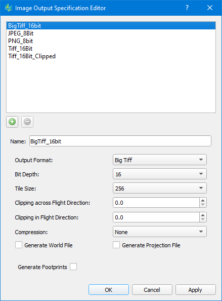
Name: Name of the template
Output format: Select between “Tiff”, "Big Tiff", “PNG” and “JPG”
Bit Depth
Select between 8, 12 or 16 bits per pixelTile Size
Select any option between 16 and 1024. Specifies the size of each internal Tiff tile size.Clipping across Flight Direction / in Flight Direction
Allows the user to specify an image clip in percent of the image size.Compression: Select between “LZW”, “Deflate”, "JPEG-LS" or "JPEG"
JPEG compression is only available for 8bit and 12bit output
If JPEG is selected, the user needs to set a Quality factor ranging from 1 (maximum compression) to 100 (minimum compression).
Generate World File
Optionally generate a world file for TIFF output formats
World file is always created for PNG and JPG output formats
Generate Projection File
Optionally generate a projection file for TIFF output formats. In case the chose coordinate reference system for TIFF output is not defined by EPSG, a projection file will be written to store the well-known text representation
Projection file is always created for JPG and PNG formats
Generate Footprints
Will generate a shapefile (.shp) with a corresponding .prj file that contains a polygon that describes the footprint of the output product
Infocloud Output
The Infocloud output template specifies the format and content of the output files that are generated for the point cloud. This template only applies to Infocloud point clouds. Clicking on the green plus icon a new template is created.
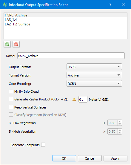
Name: Name of the template
Output format: "HSPC (Hexagon Smart Point Cloud)", "LAS (LASer file format)" and "LAZ (compressed LAS)"
Format Version: HPSC - choose Archive or Non Archive, LAS/LAZ - choose version 1.4 or 1.2
Color Encoding: choose RGB or RGBN. RGBN is only supported for LAS 1.4 and HSPC
Minify Info Cloud: apply 2 to 1 down sampling of the input Product Type Extraction Mode in the output point cloud
Generate Raster Product: A multi-band image will be generated where the last band contains the height value. The GSD for the output image must be specified
Keep Vertical Surfaces: Maintains points along vertical surfaces (important for urban mapping). If unchecked points with same position, but different heights will be removed
Classify Vegetation: Is currently not supported
Generate Footprints: Will generate a shapefile (.shp) with a corresponding .prj file that contains a polygon that describes the footprint of the output product
3D Model Output
The 3D Model Output template defines the format of the resulting building file.
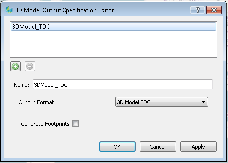
Name: Name of the template
Output Format
File format for the resulting building model can be defined: 3D Model TDC
Only the 3D Model TDC format is available now because of the optimized workflow (QC, Texturing) for that format. Other formats like OBJ or CityGML can be exported from the TDC format by using the export functionality in the "Tools" menu.Generate Footprints: if enabled, a shape file per building rooftop polygon will be added into the specified output directory after the Building generation process
LiDAR Output
The LiDAR Output template defines the format, version and specification of the point cloud.
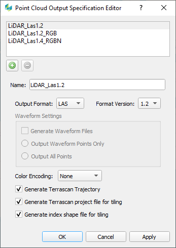
Output Format: HSPC, LAS, LAZ
Format Version: HSPC - choose Archive or Non Archive, LAS/LAZ - choose version 1.4 or 1.2
Waveform Settings
Generate Waveform files: if checked will create the required waveform data package files
All Points / Waveform Points only: specifies which points to include when generating point clouds with waveform
Color Encoding: Choose RGB or RGBN. RGBN is only supported for LAS 1.4 and HSPC.
Generate Terrascan trajectory file: generates the required trajectory to open the point cloud within Terrasolid
Generate Terrascan project file: allows to directly open the tiled output within Terrasolid
Generate index shape file: generates an overview of the tiles generated
A Terrascan project and index file will only be generated if a Tile/Shape file is used in the product generation.
DEM Output
The DEM output template defines the format to use for DEM products.
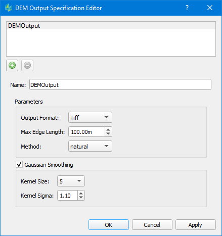
Output Format: currently only TIFF is supported as output format
Max Edge Length: prevent extrapolation artifacts at point cloud edge by limiting the max triangle edge lenght
Method: Choose one
natural: Natural Neighbor (Sibson) interpolation
plane: plane interpolation
idw: Inverse Distance Weighted interpolation
nearest: nearest neighbor interpolation
Gaussian Smoothing: optionally smooth the DEM raster output by Gaussian filter
HxMap will generate a tiled TIFF output and additionaly a multi-DEM text file that combines the individual TIFF files together. Both TIFF files as well as the multi-DEM text file can be used throughout the HxMap workflow as height reference.