
HxMap allows the user to export position and orientation metadata for images in different formats for third-party applications.
To export the data, select images from the data source, then choose Tools menu -> Export EOP or Export Footprints in the Quality Control, Triangulation, or Product Generation perspective.
Export EOP
Export EOP tool creates position and orientation metadata and optionally camera metadata for 3rd party photogrammetric workstation software. See Customize CSV Export to configure camera metadata export.
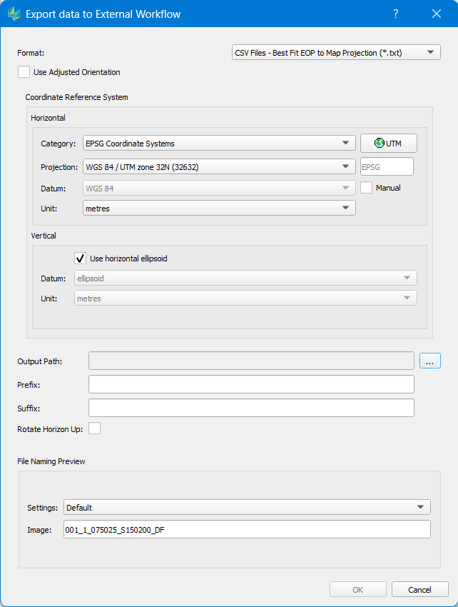
Format
HxMap supports EOP export in the following formats.
|
Format |
Description |
|---|---|
|
CSV |
Exterior and camera model parameters for third-party workflow support. CSV export supports EOP computation in two different methods.
|
|
LPS |
Exterior parameters, camera model, and image measurements (if available from HxMap APM) formatted for the IMAGINE Photogrammetry / ORIMA triangulation workflow. |
|
GORI |
Interior and exterior parameters for each image individually and used in legacy Tridicon 3D modelling workflows (CityModeller, BuildingFinder, TextureMapper etc). |
|
IPAS CO+ (deprecated) |
Exterior, installation, and metadata parameters formatted for boresight and principle point calculation in Leica IPAS CO+ application.
|
Use Adjusted Orientation
Export adjusted EOPs based on HxMap triangulation result. Only images with adjustment result will be included in the export in this case
Coordinate Reference System
Select a coordinate reference system for the position and orientation parameters to be transformed into. Note the differences in coordinate handling noted above between True and Best Fit. The coordinate reference system will be selected automatically based on the data source selected but can be customized by the user.
Customize CSV Export
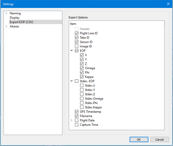
HxMap allows to customize the entries exported into the CSV files as well as their order. CSV Settings are in File menu → Settings → Export EOP(CSV). Configure which attributes to include and change their order via drag & drop. Apply with "OK".
The SensorID attribute must be included in the Export Options in order for the camera interior orientation parameter file (.iop) to be generated during export. The .iop file includes all relevant camera parameter required to setup the camera in the 3rd party application.
Export Footprints
Footprints can of data captures may be exported from Sessions, Blocks and Projects. Select the captures to export in the Data Source, then choose Tools menu → Export Footprints from Session, Quality Control and Product Generation perspectives. The tool allows to specify which coordinate system the footprints should be georeferenced in. Once the output folder is selected, HxMap will create a set of shapefiles including metadata into that location.