Once data QC is done for session data, the user can create blocks to organize data into processing units for the following processing steps.
HxMap blocks are defined by:
-
having a name and description for identification
-
a collection of strips from one or more processed session
-
default elevation source to be used in processing (global DEM, constant height etc)
-
default coordinate system used to process the block in
Blocks are used to subdivide/combine area for triangulation or product generation.
Creating a new block
To create a block, first expand the data source tree to the strip/flight plan level for an easy selection of strips. Select the strips to be added to the block.
Webcam images (e.g. captured during a TerrainMapper flight) cannot be added to a block, as they are not supposed to be used for further processing.
From the ‘Edit’ menu, select ‘Create Block …’ and enter the required attributes for the new block as shown below:
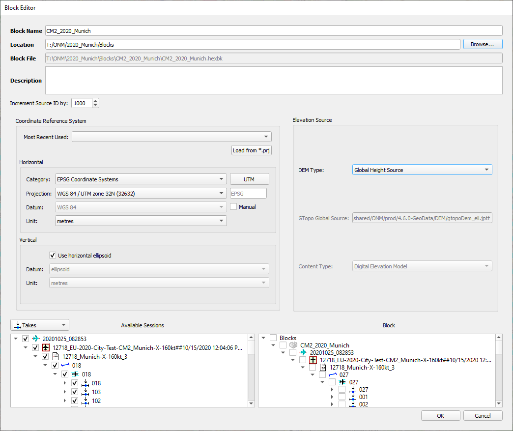
Notes on Source ID
-
By default during ingest, strips are assigned a Source ID equivalent to the Flight Line Number from the Flight Plan used to acquire them
-
During Create block or Edit block, the value in the Increment Source ID by: field will be used to pad the Flight Line Number of re-flights to ensure a unique Source ID is assigned to each strip during product generation
-
Example:
-
Flight Line Number 1 is flown 3 times to complete a project, resulting in 3 strips with Source ID 1 in processed Sessions.
-
Increment Source ID by: is set to 1000
-
During Create Block, the first flight of line 1 remains with Source ID 1, the second flight of line 1 is assigned Source ID 1001, the third flight of line 1 is assigned Source ID 2001.
-
-
The Source ID values assigned during Create Block will be assigned to point cloud products generated from the block.
Notes on CRS Selection
-
Horizontal and Vertical coordinate system will default to the last used CRS
-
Most Recent Used dropdown saves the last five used coordinate systems chosen by the user for block creation
Once the Block is created, it is added to the Data Source tree. Furthermore, a block folder is added to the specified location. This folder includes subfolders representing the used camera, a reference to the selected project data as well as a *_QC.xml (optional). The *_QC.xml contains amongst others the link of the image data to any assigned radiometric profile.
Block data layout
|
*.hexblk |
HxMap Block |
|
|
"Session" |
Block Session |
Holds folder per processed session
|
|
/cam |
|
|
|
*.hexstp |
Strip files |
|
|
*.hexrad |
Radiometric corrections |
Dark pixel, Gradient and Radiometric adjustment correction per strip (depending on the sensor) |