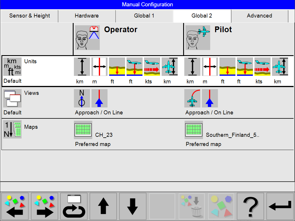
The Global 2 tab show a summarized overview of the parameters of the following configuration sections:
-
Units
-
Views
-
Maps
Enter Global 2 Configuration
Select
Select
In the main configuration dialog a summarized overview of the parameters of the selected configuration is given. This is also the entry point for changing, editing and creating configurations.
Navigation and Interaction
The selected configuration is shown with a whit background and marked with a thicker outline.
Use
Use
Select
Select
Select
If the predefined sets matches, select [Return] to open the dialog for ‘Save’, ‘Save as’ or ‘Cancel’.
Units
Predefined sets with definition of units for operator and pilot.
|
Name |
Operator |
Pilot |
||||||||||
|---|---|---|---|---|---|---|---|---|---|---|---|---|
|
Distance |
Lateral Distance |
Terrain |
Flying Altitude |
Ground Speed |
Flying Distance |
Distance |
Lateral Distance |
Terrain |
Flying Altitude |
Ground Speed |
Flying Distance |
|
|
Default |
km |
m |
feet |
feet |
knots |
km |
km |
m |
feet |
feet |
knots |
km |
|
Metric 1 |
km |
m |
m |
m |
knots |
km |
km |
m |
feet |
feet |
knots |
km |
|
Metric 2 |
km |
m |
m |
m |
km/h |
km |
km |
m |
m |
m |
km/h |
km |
|
Metric 3 |
km |
m |
m |
m |
km/h |
km |
km |
m |
feet |
feet |
knots |
nautical mile |
|
Metric 4 |
km |
m |
m |
m |
knots |
km |
nautical mile |
m |
feet |
feet |
knots |
nautical mile |
|
Metric 5 |
km |
m |
feet |
feet |
knots |
km |
nautical mile |
m |
feet |
feet |
knots |
nautical mile |
|
NauticMix 1 |
nautical mile |
m |
m |
m |
knots |
nautical mile |
nautical mile |
m |
feet |
feet |
knots |
nautical mile |
|
NauticMix 2 |
nautical mile |
m |
feet |
feet |
knots |
nautical mile |
nautical mile |
m |
feet |
feet |
knots |
nautical mile |
|
NauticMix 3 |
nautical mile |
feet |
feet |
feet |
knots |
nautical mile |
nautical mile |
feet |
feet |
feet |
knots |
nautical mile |
|
Imperial 1 |
mile |
feet |
feet |
feet |
knots |
nautical mile |
mile |
feet |
feet |
feet |
knots |
nautical mile |
|
Imperial 2 |
mile |
feet |
feet |
feet |
knots |
mile |
nautical mile |
feet |
feet |
feet |
knots |
nautical mile |
|
Imperial 3 |
mile |
feet |
feet |
feet |
knots |
mile |
nautical mile |
nautical mile |
feet |
feet |
knots |
nautical mile |
|
Views and Controls that display the selected unit |
Line progress control |
Track deviation control |
Altitude control |
Altitude control |
Speed control |
Aircraft to target control |
Line progress control |
Track deviation control |
Altitude control |
Altitude control |
Speed control |
Aircraft to target control |
|
Shorten or extend line |
Line deviation control |
|
|
|
|
Shorten or extend line |
Line deviation control |
|
|
|
|
|
View Configuration
The various view options are configured in the View Configuration.
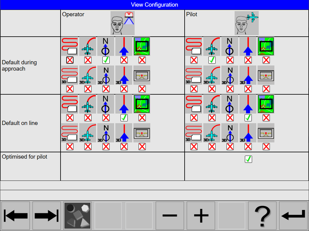
In this dialog, the following views can be set independently for the operator and the pilot:
-
default view during approaches and turns
-
default view on the line
Check Optimized for the pilot option to activate simplified controls and toolbar for the pilot. If this option is checked, the pilot’s access to Leica FlightPro is limited to flight guidance related configuration and operation only. Leica FlightPro will also not show any full screen warning or error messages on the PD61 Pilot Display in this mode.
Map Selection
The various map selection options are configured in the Map Selection.
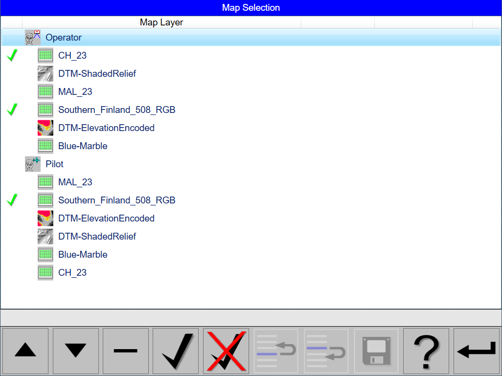
Maps Selection configuration
Introduction to the use of maps in Leica FlightPro flight guidance
During a flight Leica FlightPro can display a map layer on the following views:
-
North-up
-
Nose-up
-
Project
The data can be either
-
Bitmap Maps
-
Bitmap of DTM data
Leica FlightPro generates Elevation Encoded bitmap or Shaded Relief bitmaps
-
Vector Maps
-
Ground Control Points
-
GNSS ground reference stations
The type of background data which is displayed during flight, is configured in the dialog ‘Configuration of Guidance Project’.
Bitmap maps are uploaded by the user to the system in the Leica FlightPro File Menu. The procedure is similar as for flight plans. Bitmap maps have to be georeferenced and the map projection has to be assigned in Leica MissionPro beforehand.
SRTM DTM data are uploaded to the airborne system by using the installer provided by Leica Geosystems. Installer and data are available as Part number 850367 Global Digital Elevation Models on USB. During installing the user can select the regions to be installed. From SRTM DTM data Leica FlightPro generates automatically two types of bitmaps:
-
Elevation Encoded bitmaps.
-
Shaded Relief bitmaps.
Graphical data like vector maps, GCP and location of GNSS ground reference stations are imported and used with the flight planning. All data assigned to the project during flight planning in Leica MissionPro become part of the Project. These data are exported with the flight plans to the FPD3 file and uploaded when uploading the flight planning.
During flight execution, Leica FlightPro determines the geographic extend of the area displayed in the selected view and loads automatically a map which covers this area. Leica FlightPro checks and selects the map based on the order the user has defined in the ‘Maps’ configuration dialog.
In the Map Selection configuration dialog the user can
-
Define the order of the maps independent for operator and pilot.
-
Uncheck a map. In this case Leica FlightPro will skip this map during automatic selection
In this dialog the following can be set independently for the operator and the pilot:
-
The order Leica FlightPro selects the map for display. The top item in the list is the first item which is checked by Leica FlightPro
-
Make a map active or inactive
For safety reasons DTM-ElevationEncoded maps generated by Leica FlightPro are not colour-coded for display on the PD61 Pilot Display.