The Position control shows current position, Sun elevation and time in UTC.
Position
Operator can configuration the Position control to display the position either in WGS84 or in local
coordinates.
Leica FlightPro can display local coordinates if the transformation parameters from WGS84 to local coordinates are available. This is the case, if either the flight plan was made in Leica MissionPro or later in local coordinates or if a map with local coordinates is displayed in the map layer. If both are true, then Leica FlightPro always applies the transformation from the flight plan.
Sun Elevation
The Sun Elevation part shows information to help the operator with mission decisions. The operator can now set the minimum and maximum Sun Angle in Sun Angle tab in Flight Guidance & Sensor release Configuration view. In the Position control, The Sun Angle control now shows four different types of information.
Control symbol and text colour
All the symbols and text are shown in green in the Sun Angle control when the sun elevation is above the minimum sun elevation and below the maximum sun elevation. Otherwise, all the symbols and text are shown in black in the Sun Angle control.
☼ / O symbol
Sun Angle control shows the ☼ symbol when the sun elevation is above the minimum sun elevation and below the maximum sun elevation. Otherwise, the O symbol is shown in the Sun Angle control.
▲ / ▼
Sun Angle control shows the ▲ symbol when the sun elevation is increasing.
Sun Angle control shows the ▼ symbol when the sun elevation is decreasing.
h:mm / -:--
Sun Angle control shows the time until the sun elevation reaches the minimum sun elevation or the maximum sun elevation. If the time until the sun elevation reaches the minimum sun elevation or the maximum sun elevation is more than 9:59 then -:-- are shown.
Sun Angle control examples
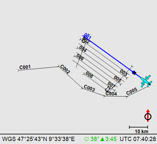
Sun elevation is 38°. The sun elevation of 38° is between the selected minimum and maximum sun elevation. The sun elevation is increasing and will be between the selected minimum and maximum sun elevation for the next 3 hours and 45 minutes.
Sun elevation is 41°. The sun elevation of 41° is between the selected minimum and maximum sun elevation. The sun elevation is decreasing and will be between the selected minimum and maximum sun elevation for the next 7 minutes.
Sun elevation is 38°. The sun elevation of 38° is below the selected
minimum sun elevation. The sun elevation is increasing. The sun elevation will be inside the selected minimum and maximum sun elevation in 9 minutes.
Sun elevation is 40°. The sun elevation of 40° is above the selected maximum sun elevation. The sun elevation is decreasing. The sun elevation will be outside the selected minimum and maximum sun elevation for at least 9 hours and 59 minutes.
Time
Time in Coordinated Universal Time (UTC).