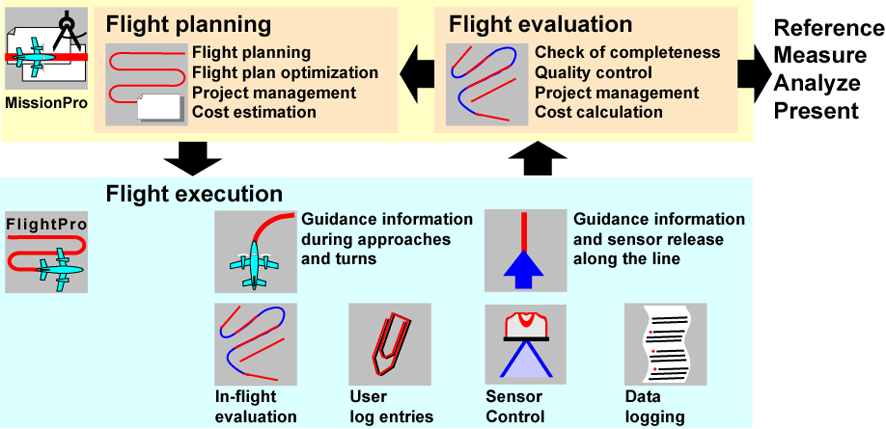
Leica FlightPro tasks
The heart of operation is the Leica FlightPro software. All aspects of the system and operation are conducted using this software. Leica FlightPro Software consists of various modules.
Sensor Control module
-
Sensor control and operation including manual system operation.
-
Controls components and shows status on views.
-
-
Configuration management
-
Allows flexible system configuration.
-
-
System monitor
-
For in-flight error detection and recovery. Supervises the system and dataflow to detect malfunction or operation out of limits.
-
-
Status data logger
-
Collects data for post flight error analysis.
-
-
Leica PAV200 or PAV100 control
-
Activates stabilization on Leica PAV200 or PAV100 during the flight line.
-
Flight Guidance module
-
Flight guidance
-
Provides flight guidance information on various views for efficient survey flight.
-
-
Device control
-
Automatic sensor release and configuration. Automatic control of Leica PAV200 or PAV100.
-
-
Flight plan management
-
Monitors progress of project execution and provides in-flight quality control.
-
Remote Control module
-
Locking Management
-
Operation of multiple user interfaces.
-
Highlights of Leica FlightPro
Leica FlightPro has a fully integrated flight guidance module. This is a key element of the software. It cuts down the flying time as it takes over the following tasks during the survey flight:
Precision GNSS-supported flight navigation
Navigation and graphical guidance information is displayed during all phases of the survey
flight:
-
Approach to the mission area
-
During the turns
-
On the flight line
Both the sensor operator and the pilot can compare the aircraft position with the desired position on their screens. The flight lines to be flown and the direction of approach can be freely selected. But also an optimal route-finder algorithm can select the nearest flight line automatically. The
best flight path from the current position to the target is displayed. Wind speed and wind direction are taken into account.
Automatic sensor and mount control
During a flight plan controlled survey flight, Leica FlightPro takes control of the system and releases the Lidar Unit and camera at the pre-planned positions. Additional release sequences can be released manually at any time. The Leica PAV200 or PAV100 sensor mount is also controlled automatically.
Monitoring the progress of project execution
For efficient flight mission is important to know already in-flight which lines are not yet flown and which lines need to be re-flown due to various reasons such as clouds. Leica FlightPro monitors the project execution. It keeps track of the progress and supports in-flight evaluation. If
desired, previous flights are taken into account.
In-flight quality control
During the survey flight, Leica FlightPro monitors various parameters such as GNSS quality, navigation accuracy along the flight line, sensor status as well as other error conditions. If the survey data are unusable, flight lines or parts of flight lines are marked accordingly. The user can
also manually mark unusable parts. This information is used for accurate in-flight or post-flight evaluation repetition.
Accurate repetition of specific flight sections
If a specific portion of a flight line is missed, Leica FlightPro will exactly guide the pilot to the missing parts. For a complete coverage of the project area, the missing part of the line can be extended by a number of frames.
Flexible user log entries
This feature allows the user to make text entries into the logfile during flight execution. The entries are time tagged and passed along with the flight and image data to the flight evaluation and data post-processing step.
Data logging for post flight evaluation
Post-flight mission analysis is essential to manage aerial survey projects, especially for large projects if more than one aircraft is in use. All data required to evaluate flights are stored by Leica FlightPro during the flight execution.
Leica FlightPro - optimal interface in the Leica Geosystems work flow
Perfect integration of Hardware and Software into one system is the key for most effective work. Leica Geosystems' proven integrated workflow starts with flight planning and ends with the deliverable. With Leica FlightPro the system is tightly integrated in the entire workflow.
This increases productivity and cuts cost.